LAC ROUGE GRAPHITE PROPERTY SUMMARY
HIGHLIGHTS
- Consists of 84 mineral claims in one contiguous block totalling 4,982 hectares land near the town of Mont-Laurier in southern Québec.
- Excellent infrastructure support, road accessible, located 150 kilometres from Montreal; water, power and manpower available locally.
- Located in a very active graphite exploration and production area, only 3 kilometres to the east of TIMCAL’s Lac des Iles graphite mine in Quebec which is a world class deposit producing 25,000 tonnes of graphite annually. There are several graphite showings and past producing mines in its vicinity.
- Underlain by the same geological environment as the TIMCAL’s Lac des Iles mine, consisting of Metasedimentary Belt of the Grenville Province which includes quartzofeldspathic rocks, quartzite, biotite gneiss, limestone/marble and locally pegmatitic quartzofeldspathic rocks.
- Graphite mineralization in the adjoining areas is typically present in shear zones within gneisses where the graphite content usually ranges from 3% to 10% Cg exhibiting flakes up to 3 millimetres (mm) in diameter.
- Available airborne geophysical data from MRNF indicates a large magnetic anomaly on the property which can be a potential target for future graphite exploration work. The anomaly covers an area of approximately 4 km x 4 km area around Lac Rouge.
- A two phase exploration program is recommended which include data compilation, prospecting sampling, ground geophysical survey, and trenching.
LOCATION AND INFRASTRUCTURE
The Lac Rouge Graphite Property (the “Property”) consists of 84 mineral claims in one contiguous block totalling 4,982 hectares land near the town of Mont-Laurier in southern Québec. It has excellent infrastructure support, easily accessible through a provincial highway (Route 117) from Montréal, and then following secondary roads 309 and 311. Various tertiary / forest roads provide access to different claims on the Property. The town of Mont-Laurier is located about 20 kilometres to the north, Montréal 150 kilometres to the southeast, and Ottawa 125 kilometres to the south of the Property. Mon-Laurier is also connected to Montreal via rail. Water, electricity and mining related work force are available locally. Local economy is based on agriculture, farming, mining, forestry and tourism.
GEOLOGY AND MINERALIZATION
The Property is located in a very active graphite exploration and production area. It is located approximately 3 kilometres to the east of TIMCAL’s Lac des Iles graphite mine in Quebec which is a world class deposit producing 25,000 tonnes of graphite annually. The open pit mine is in operation since 1989 with an onsite plant ranked 5th in the world production of graphite. The mine is operated by Timcal Graphite & Carbon which is a subsidiary of Imerys S.A., a French multinational company. The mine has an average grade of 7.5% Cg (graphite carbon) and has been producing 50 different graphite products for various graphite end users around the globe. Source: http://www.mern.gouv.qc.ca/mines/industrie/mineraux/mineraux-exploitation-graphite.jsp.
Graniz’s graphite deposit belonging to Graniz Mondal Inc. is located 50 kilometres to the northeast of the property. There are several other graphite occurrences and historical mines in the surrounding area which are known since the 19th century.
The Lac Rouge Graphite Property lies within the same geological environment as the TIMCAL’s Lac des Iles mine, consisting of Metasedimentary Belt of the Grenville Province which includes quartzofeldspathic rocks, quartzite, biotite gneiss, limestone/marble and locally pegmatitic quartzofeldspathic rocks. Graphite is commonly found in the Granville Province rocks throughout this region and has been commercially mined from a number of deposits located between Mount Laurier in the north to the Ottawa River in the south. The graphite mineralization around the property area is common as minute flakes disseminated in the crystalline limestone / marble and occasionally also in the quartzites and gneisses. Richer showings are known at some localities including TIMCAL’s graphite mine. Graphite is located in shear zones within gneisses where the graphite content usually ranges from 3% to 10% Cg exhibiting flakes up to 3 millimetres (mm) in diameter. Large flake graphite is generally considered as 0.2 mm and above. The graphite is considered to be introduced in these rocks by quartz-graphite injection from deeper source and redistributed through fractured incompetent beds of limestone creating graphite mineralization channels. Alternatively, another theory believes graphite mineralization was derived from algae or through decomposition of the calcium carbonate molecule liberating the carbon atom through metamorphic reactions. Slow cooling of the mineralized material has produced crystalline large flake graphite.
HISTRORICAL EXPLORATION
The Property and the surrounding area, considered prospective for large flake, crystalline graphite, has an historic record of exploration. Numerous flake graphite occurrences in the adjacent areas are some of the oldest graphite showings in Canada, having been discovered in the late 1800’s and early 1900’s when there was a considerable interest in graphite due to its properties as a lubricant in the automobile industry. The Quebec Ministry of Energy and Mines (MRNF) maintain record of past exploration and development work carried out on mineral claims. A review of the airborne geophysical data indicates a large magnetic anomaly on the property which can be a potential target for future graphite exploration work. The anomaly covers an area of approximately 4 km x 4 km area around Lac Rouge.
RECOMMENDED EXPLORATION WORK
The following phased work program is recommended for the Property, where each phase is contingent upon the results of the previous phase.
Phase 1 – Data Compilation and Geological Reconnaissance Work
This work includes two stages; the first stage comprises compilation of all the historical geological, geophysical and geochemical data available on the Property, and putting it into a database to generate several layers of maps in GIS format for further interpretation. In the second stage, the geological reconnaissance program will be carried out. This program includes the following tasks:
- Reconnaissance level prospecting, sampling and limited geological mapping of the area around Lac Rouge and other areas on the Property, especially the contact zones between paragneiss and crystalline limestone / marble;
- Detailed sampling of potential graphite bearing rock units exposed within the Property area;
- Ground geophysical survey including Very Low Frequency (VLF) and horizontal loop electromagnetic (HLEM) survey; and
- Identifying areas for detailed trenching and sampling work.
Phase 2 – Trenching and Sampling
This work will help to confirm the targets identified through ground geophysical survey and reconnaissance geological work. The scope of work and location of trenches will be based on the results of Phase 1 investigations.
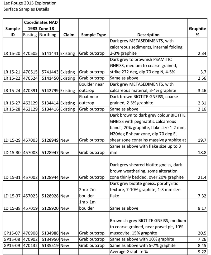
Sample Results
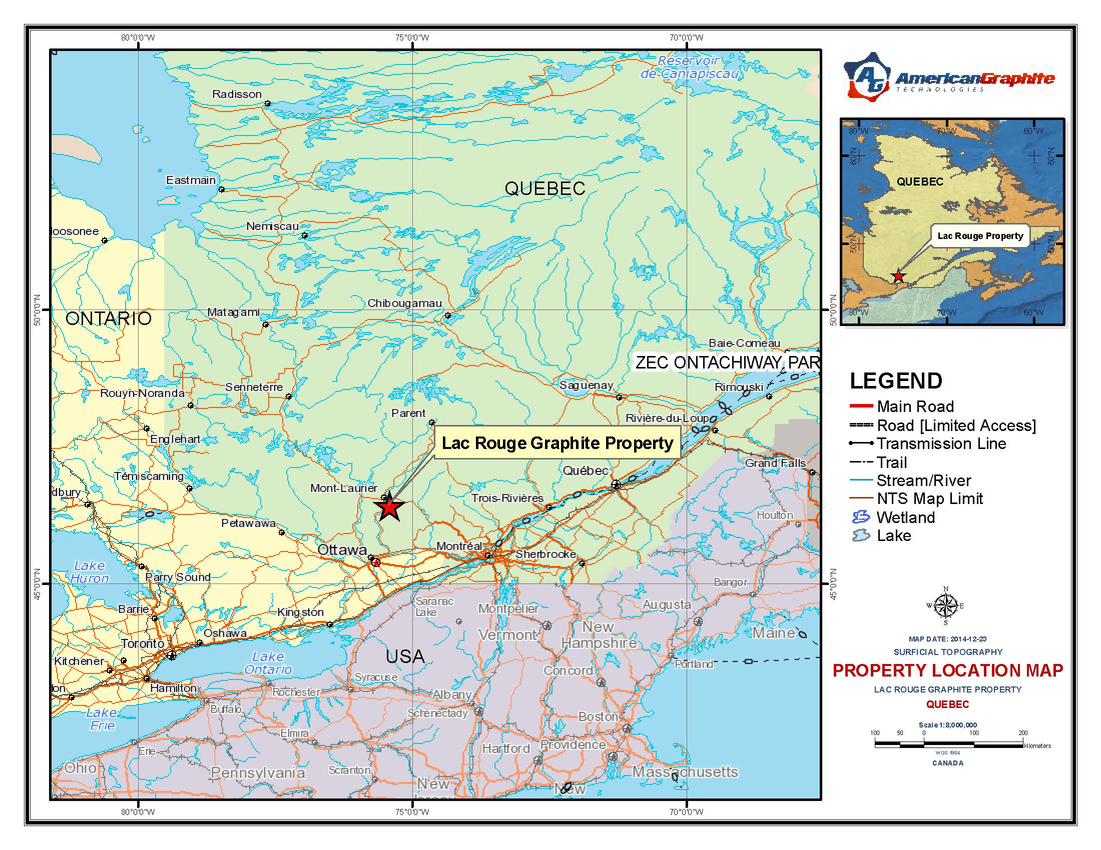
Figure 1: Property Location
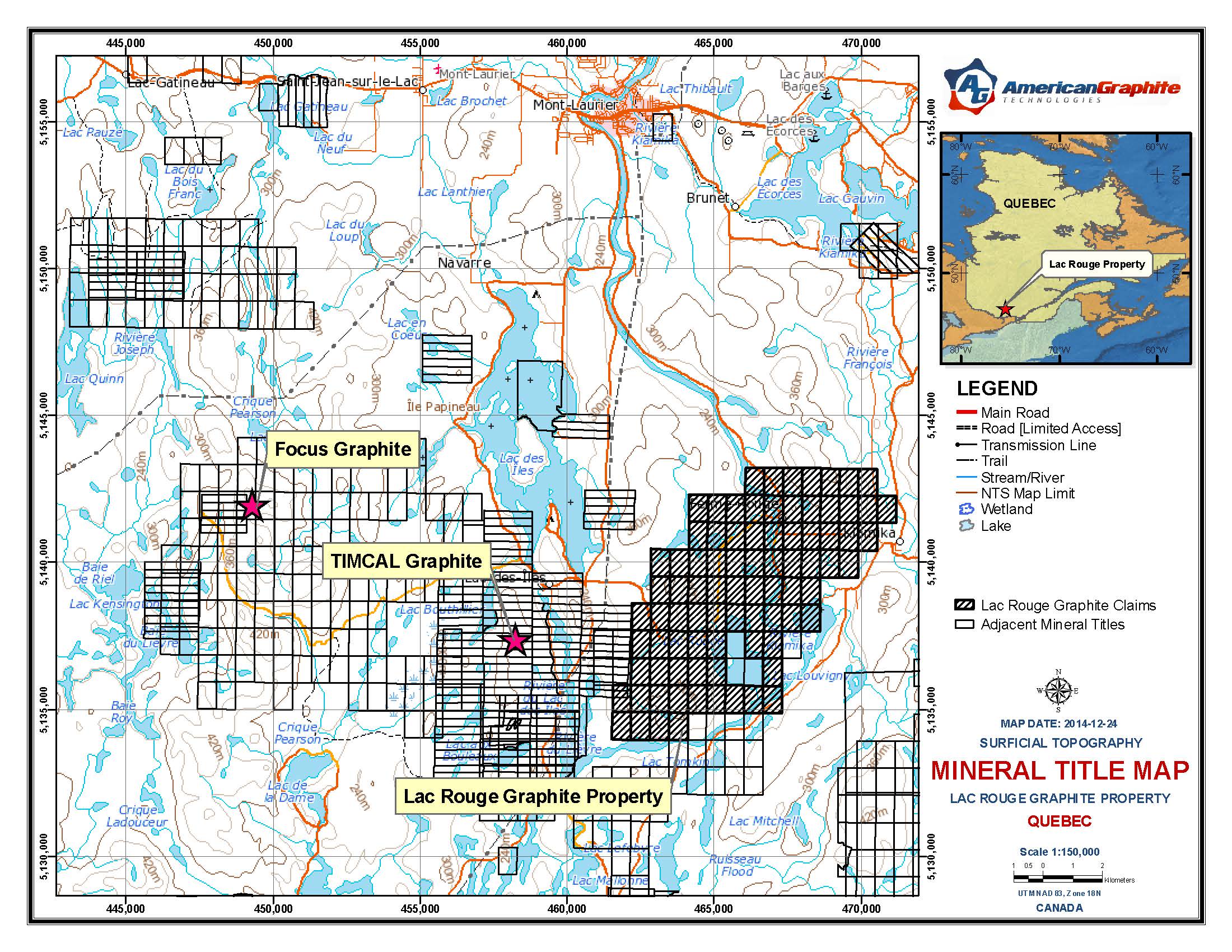
Figure 2: Property claims map showing graphite projects in the vicinity
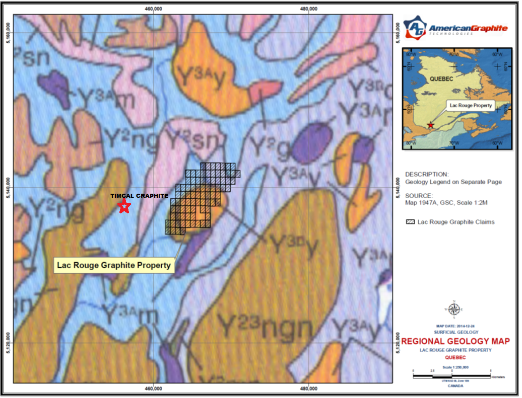
Figure 3: Geological map indicating Grenville Province rocks underlying the Property and the surrounding areas (Y1 – Early Meso Proterozoic: 1350 to 1600 Ma; Y2 – Mid Meso Proterozoic: 1200 to 1350 Ma; Y3 – Late Meso Proterozoic: 900 to 1200 Ma; and Y23 – Mid-Late Meso Proterozoic ~ 1200 Ma)
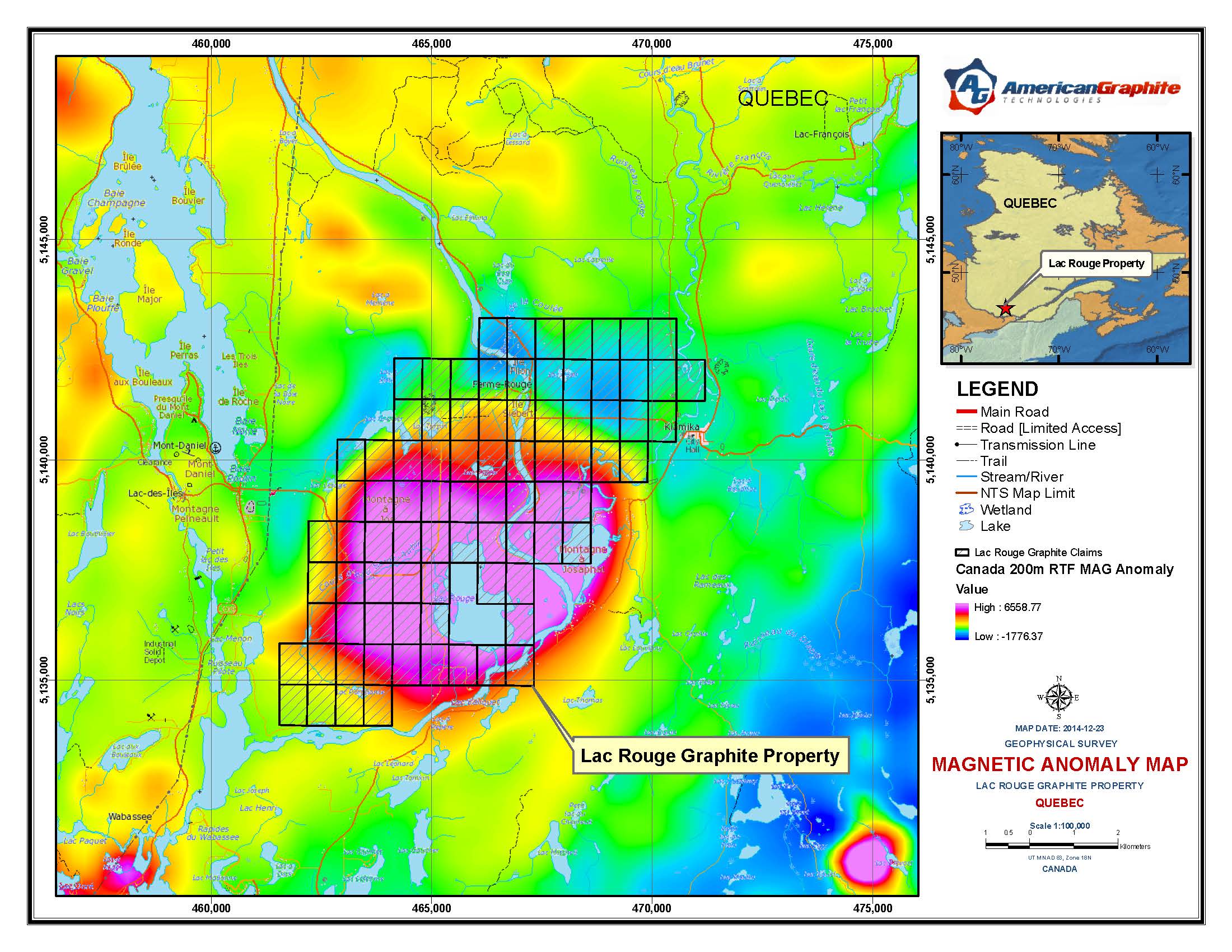
Figure 4: High magnetic anomaly around Lac Rouge, a potential graphite exploration target on the Property.
-
Graphene
This "Miracle Material" is 200X stronger than steel, ultra thin, flexible and may one day replace silicone in computer chips
LEARN MORE >>
-
Graphite
Graphite demand is expected to increase by +50% by 2020. Demand from high tech applications is projected to be dramatic
LEARN MORE >>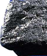
-
 Latest News
- Queen's University and Eagle Graphite Announce Grant to Test Multi-Layered Graphene in Plastic Composites - Stockhouse June 3, 2017
- R&D Special Focus: Graphene - R & D Magazine May 31, 2017
- NextSource Materials' Modular Graphite Game Plan - InvestorIntel May 26, 2017
- Zenyatta Enters the Next Phase to Test Concrete Admixture ... - AZoNano May 26, 2017
- Graphene City: Research Hub Accelerates Innovation - R & D Magazine May 25, 2017